North America has a large number of rivers, both large and small. But since there is a lot of precipitation in this part of the continent, it is mainly rain and snow supply of the rivers here. They are also divided into three groups according to their belonging to the basins of the oceans: Atlantic, Pacific and Arctic. The largest of these rivers is the Mississippi, which flows only in the United States. It also ranks third in the world in length.
Many of these rivers have reservoirs that contain huge reserves of fresh water. Also, some of them are navigable, which means they play an important role in those states and regions where they flow. A large number of hydroelectric power plants have been built on them, and they supply electricity to many cities. Rivers also play a significant role in agriculture.
The longest rivers in North America
List of the largest waterways on the continent.
Mississippi
The main artery in North America. It flows in the United States in ten states. And the source is located in Minnesota. It ends with a large delta in the Gulf of Mexico. Divided into Top and Bottom. The division border is in the state of Illinois. The largest tributary of this river is the Missouri. And the Mississippi Valley is a fertile region, as there is a large layer of silt deposits.
The length of the river is 3770 km.
Missouri
It is a tributary of the Mississippi. Its beginning is in the Rocky Mountains, in the state of Montana on the border with Canada. It flows on the territory of ten US states, two provinces of Canada. The largest tributaries are: Platt, Kansas, Osage, Yellowstone. Shipping, which developed rapidly here in the 19th-20th centuries, is now in decline. Ranked ninth in the United States in terms of water consumption.
The length of the river is 3767 km.

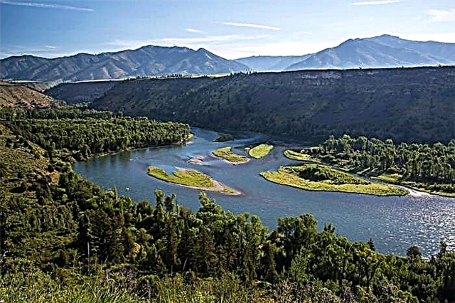
Yukon
The name translates as "Big River". It originates from Lake Atlin. This is Canada, British Columbia. Only at its source the river has a mountainous character, later it becomes completely flat. The main tributaries are: Klondike, Fortimail, Steward, Sixtimile, Shandalar, Koyukuk. It flows through the state of Alaska to the USA, northwest of Canada. It flows into the Bering Sea.
The length of the river is 3187 km.

Rio Grande
This river is the border between the United States and Mexico. It is the fourth longest in the United States. It originates in the US state of Colorado in the San Juan mountains. Until 2003, the river flowed into the Gulf of Mexico. Now it does not reach the bay 150 meters. Not navigable, and since 1950 the river has been gradually sweeping. Now the main reason for its drying out is climatic changes.
The length of the river is 3034 km.

Arkansas
Ranked sixth in the United States in length. It originates in the Rocky Mountains. Then it flows through the four states of the United States. The river crosses the Great and Central Plains. It is navigable and plays an important role in the country's economy. After all, it forms large reservoirs. However, as a result of the withdrawal of water for the reservoirs, the river became noticeably shallow. It has several tributaries: Pawnee, Walnut, Fountain Creek, Cimarron, Poto.
The length of the river is 2364 km.

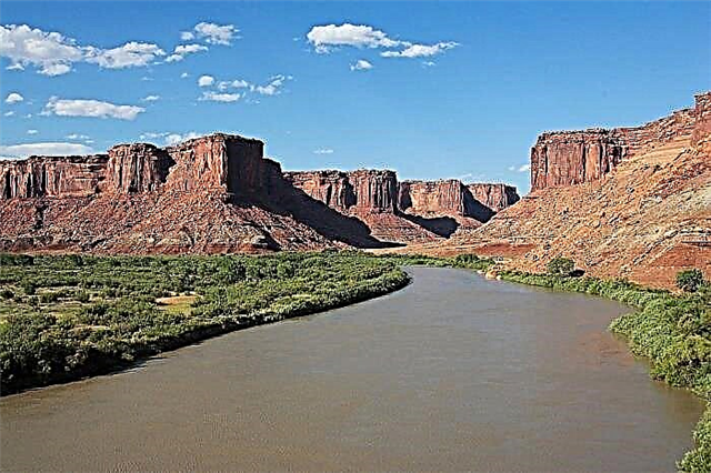
Colorado
Ranks seventh in the catchment area in North America. It begins in the state of Colorado in the Rocky Mountains. It flows through the Grand Canyon. The river flows into the Gulf of California, Pacific Ocean. However, in the last twenty years, this has happened only a few times and after large floods. It flows through three US states and two Mexican states. Its largest tributaries are the Green River and Gila.
The length of the river is 2334 km.

Red river
This is a tributary of the Mississippi. The name translates as "Red River", thanks to the soil with a high clay content on the banks of the river. It originates in Texas at the confluence of two rivers. It flows through four states: Texas, Louisiana, Oklahoma, Arkansas. And crosses the Mexican Lowland. In the lower reaches it is divided into two branches: the Old River and Atchafalaya. The second arm flows into the Gulf of Mexico. Meals are mainly rain-fed, therefore irregular.
The length of the river is 2190 km.

Colombia
Ranked fourth among the rivers in the United States in length. It flows through the following US states: Washington, Oregon and the Canadian province of British Columbia. The river flows into the Pacific Ocean. It has built 14 hydroelectric power plants and is the largest in terms of hydropower production. The largest concrete dam in the world was built on it. There is also a large reservoir - Roosevelt Lake.
The length of the river is 2000 km.

Pease
It flows through the Canadian provinces: British Columbia, Alberta. It is part of the Mackenzie River System. The river originates in the Rocky Mountains in Lake Williston. Agriculture and forestry are developed in the river valley. The Bennett Dam has been built here, which provides hydropower and helps prevent floods. The largest tributary is the Finley.
The length of the river is 1923 km.

Mackenzie
One of the largest rivers in Canada. Named after Alexander Mackenzie. It is navigable all over. It originates from the Great Slave Lake in Canada. It flows into the Arctic Ocean. The river basin is located in several climatic zones at once - from temperate to arctic. It has several tributaries - Willoughlake, Blackwater, Trout, Ruth, Wrigley, Johnson, Redston.
The length of the river is 1738 km.

Snake
The second name is Serpent River. It is a tributary of Colombia. Ranked thirteenth in length in the United States. It starts at an altitude of three thousand meters in Yellowstone National Park. Passes through the eastern part of the Columbia Plateau. And flows through four states: Wyoming, Idaho, Oregon, Washington. It flows into the Pacific Ocean. The pool is mainly located in the mountains.
The length of the river is 1735 km.
Churchill
The river originates in the Canadian province of Alberta. The main tributaries are: Raindeer River, Beaver. Passes through three provinces: Alberta, Saskatchewan, Manitoba. It is considered the largest in northeastern Canada. It flows into Good's Bay and then into the Atlantic Ocean. Located at the intersection of the bearish path. There is a large colony of polar bears here.
The length of the river is 1609 km.

Ohio
It is a tributary of the Mississippi. The river begins on the Allegheny Plateau, which is located next to the Appalachian mountain range. It flows through the following American states: Ohio, Virginia, Kentucky, Pennsylvania, Illinois, Indiana. It has several tributaries: Canova, Salt, Kentucky, Guyandotte, Shade, Wabash. The river is one of the most important waterways in the United States. Almost completely navigable.
The length of the river is 1579 km.

Canadian river
It is a right tributary of the Arkansas. Crosses four US states: Oklahoma, New Mexico, Colorado, Texas. The beginning of the river is on the Sanghe de Cristo ridge in the Rocky Mountains. It flows through the Great and Central Plains. At the end of its path it merges with the Arkansas River. Its waters are used in agriculture for irrigation. And the largest reservoir is Lake Euphola.
The length of the river is 1500 km.

Pecos
It is a left tributary of the Rio Grande. It flows on the territory of two American states: Texas, New Mexico. And it originates on the slopes of the Sangre de Cristo in the Rocky Mountains. Crosses the La po Estacado plateau. Food is rain and ground. Its waters are used for irrigation. There are several dams and reservoirs. Its largest reservoirs are McMillan, Red Bluff, Alamogordo.
The length of the river is 1490 km.

Tennessee
It is the longest tributary of the Ohio and part of the Mississippi Basin. It flows through the territory of five US states. Formed at the confluence of two rivers on the slopes of the Appalachians. Its largest tributaries are: Ocky, Clinch, Sequachi, Hivassi, Payne Rock. Navigation is well developed on the river. Has a reservoir. The largest of them are: Kentucky, Norris, Wilson, Chickamoga.
The length of the river is 1470 km.

South Saskatchewan
Formed at the confluence of the Bow and Oldman Rivers in the Canadian Rockies.It flows through the territory of two Canadian provinces: Saskatchewan and Alberta. It is one of the rivers that form the Saskatchewan River and the largest basin in North America. Its name means "South Fast River". Included in the list of protected rivers in Canada. Its largest tributary is the Red Deer.
The length of the river is 1392 km.

Colorado
Ranked eighteenth longest in the United States. It originates on the Llano Estacado plateau south of Lubbock in Texas. It flows through several reservoirs: Buchanan, Travis, Lyndon Johnson. It flows into the Gulf of Mexico. The waters of the river are used for electricity generation, irrigation, and urban needs. The name translated from Spanish means "Colored". Not to be confused with the river of the same name that flows through the Grand Canyon.
The length of the river is 1387 km.

Fraser
It is the main river of the Canadian province of British Columbia, but also a small part of it flows through the United States. Its origin is in Mount Robson Park, Canada. It flows into the Georgia Strait and forms a delta. The river is fed mainly by snow and rain. It got its name in honor of the researcher Simon Fraser.
The length of the river is 1370 km.

Brazos
Ranked eleventh longest in the United States. The river forms from the confluence of the Salt Fork Bratsors and Double Mountain Fork rivers on the Llano Estacado Plateau in New Mexico. The main tributaries of the river are Navasota, Bosque, Little River. Three dams have been built on it, which form lakes. Its waters are used for irrigation.
The length of the river is 1352 km.

North Saskatchewan
Formed from a glacier in the Canadian Rockies. It flows through the Canadian provinces of Saskatchewan, Alberta. Crosses Banff National Park. This river, at its confluence with South Saskatchewan, forms the Saskatchewan River. There is a large reservoir on it - Abraham. It feeds on melt and rainwater. The river is navigable. Included in the list of protected rivers in Canada.
The length of the river is 1287 km.

Ottawa
This is the largest tributary of St. Lawrence. The river originates from Lake Kapimichigama, which is located on the Laurentian Upland. It passes through two Canadian provinces: Quebec and Ontario. There are seven hydroelectric power plants on it. And the main tributaries are: Coulonge, Lievre, Mattava, Gatineau, Rideau. The lower reaches of the river are navigable. Food from rain and melt water.
The length of the river is 1271 km.

Athabasca
It originates from a large glacier in the Jasper National Park, which is located in the Canadian province of Alberta. It flows into Lake Tabaska, forming a large delta. At the same time, it is part of the freshwater delta that runs through the Wood Buffalo National Park. This is one of the largest parks in the world. It also belongs to the Mackenzie river system.
The length of the river is 1231 km.

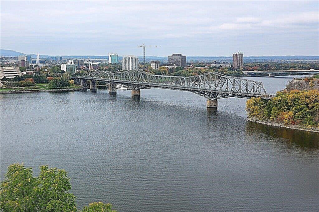
St. Lawrence River
It flows in Canada and the United States. Connects the Great Lakes to the Atlantic Ocean. It originates from Lake Ontario in the United States. It flows into the Gulf of St. Lawrence on the Atlantic coast of Canada. The flow of the entire Great Lakes system passes through this river. Its main tributaries are Richelieu, Osuegatchi, Shodier, Bekankur, Batiskan.
The length of the river is 1197 km.

Green River
It is the longest tributary of the Colorado River. It passes through three US states: Utah, Colorado and Wyoming. It begins in the Wind River mountain range in Wyoming. It flows into Colorado in the Canyonlands National Park. Thanks to the built platinum, the river has a large reservoir Fortenelle. The largest tributaries: Yampa, White River. Duchesne, Price.
The length of the river is 1175 km.
Milk
It is the third longest tributary of the Missouri. It flows through the US state of Montana and the Canadian province of Alberta. Its origin is in the Rocky Mountains in the United States. Formed at the merger of Middle Fork and South Fork. The name of the river is translated as "Milk". Its waters are indeed whitish in color. There is the Fresno platinum on the river.
The length of the river is 1173 km.

White River
It flows on the territory of two US states: Arkansas, Missouri. It is the lower tributary of the Mississippi River. There are several large reservoirs along its length. The river originates in the Boston Mountains in northwest Arkansas. The name translates as "White River". Part of the river is navigable. Its tributaries are: Cash, Little Red River, Roaring River, Kings River.
The length of the river is 1162 km.

James
It is a left tributary of the Missouri. It flows in the territory of North and South Dakota in the United States. Its origin is in Wells County, North Dakota. And in Missouri, this river flows near the city of Yankton. Near the town of Jamestown there is platinum, which forms a large reservoir. It feeds on melt and rainwater.
The length of the river is 1143 km.
Trinity
Flows through the territory of Texas in the United States. It is the longest river in this state. And it originates at the confluence of the Western and Eastern Trinity rivers. It has many tributaries. The river is fed mainly by rain. There are reservoirs in the pool.
The length of the river is 1140 km.

Kuskokim
Takes 17th place in the USA in terms of pool area. It flows in the state of Alaska in the United States. It is formed as a result of the confluence of the North Kuskokwim and South Kuskokwim rivers. The river flows into the Kuskokwim Bay of the Bering Sea, forming a large delta. For six months, it is covered with ice. The largest tributary of this river: Aniak. Its lower part is navigable.
The length of the river is 1130 km.