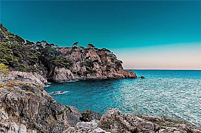
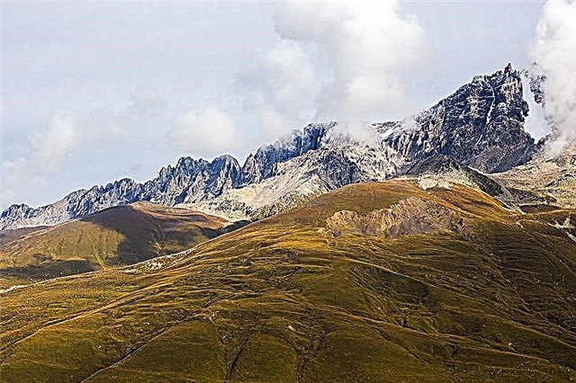
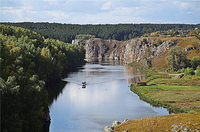
The Urals stretches for 2.5 thousand km from the Arctic Ocean to the Kazakh semi-desert lands. It has a complex geological structure, a wide variety of natural conditions that affect the rivers of the region. There are about 5 thousand of them here. Most have a mountainous character, mainly in the upper reaches, many rapids, rifts, coastal cliffs, caves and grottoes. All these rivers are interesting for rafting and combined hiking.
The abundance and variety of fish makes them attractive to anglers. The rivers of the Urals are of great economic importance; they serve as sources of water supply for a large number of settlements and large enterprises. At the same time, many of them suffer from intense industrial waste pollution, therefore, the issues of water protection and purification in the region are especially urgent.
The longest Ural rivers
List of the largest waterways in the Urals!
Ural
Starts in Bashkortostan, in the Southern Urals. Later it crosses the Chelyabinsk and Orenburg regions, and already on Kazakh land flows into the Caspian Sea. By its length, the river ranks third in Europe. Several reservoirs have been created in the Urals, the largest is Iriklinskoye. Plenty of fish. The river is suitable for tourist rafting, especially within the Orenburg region. A number of settlements are located on the shores, including large industrial centers.
River length - 2428 km

Pechora
The largest river is Komi and Nenets Autonomous Okrug. It has 35 thousand tributaries and 60 thousand lakes. It flows into the Barents Sea. In the upper reaches, the river is mountainous, with rapids and rifts. In the middle and lower reaches it has a flat character and is navigable. Visited by tourists, rafters and fishermen. Located in a hard-to-reach place, you can only get there by rail. Therefore, there are still corners of wild nature, some of them are part of the Pechora-Ilychsky nature reserve.
River length - 1809 km

Kama
It begins on the territory of Udmurtia, then carries its waters through the Kirov region, Perm region, as well as Bashkiria and Tatarstan. The largest tributary of the Volga has more than 70 thousand rivers in its basin. 3 reservoirs and hydroelectric power plants have been built. Large navigable artery. Among the coastal cities - Sarapul, Perm, Berezniki, Naberezhnye Chelny, etc. There are many options for outdoor activities, hiking, rafting, fishing.
River length - 1805 km

White
The river is the longest in Bashkiria. It originates in the mountains of the Southern Urals and flows into the Nizhnekamsk reservoir. It starts as a mountain river, then spreads through the valley. The shores are rich in sights - numerous grottoes and caves, former mining factories, the famous Kapova cave with rock paintings, the Tabynsk fortress. 2 reservoirs have been built on Belaya. The river is attractive for boaters and fishing enthusiasts.
River length - 1430 km

Tour
Located in the Sverdlovsk and Tyumen regions. Starts on the slopes of the Middle Urals. In the upper reaches it has a mountainous character. The channel is meandering, with multiple rifts. It flows into the Tobol. The Verkhoturskaya hydroelectric power station was built on the river. There are 3 reservoirs. Several routes have been developed for water tourists. There is a lot of fish, industrial fishing is carried out. In the mountainous part there are deposits of copper, ore, gold and platinum. Cities on the river - Tyumen, Verkhoturye, Turinsk.
River length - 1030 km

Ufa
The source is Lake Ufimskoe at the foot of the Uraltau ridge. It crosses the Sverdlovsk and Chelyabinsk regions, as well as the territory of Bashkortostan. White tributary. The Pavlovsk hydroelectric power station, two reservoirs have been created on the river, and two reserves and two national parks have been organized. Water trips are popular, there are practically no difficult sections. The river is famous for its excellent fishing. Large cities are Krasnoufimsk, Ufa, Mikhailovsk.
River length - 918 km

Tavda
The largest waterway in the Sverdlovsk region. The source lies on the slopes of the Middle Urals. It also flows through the Tyumen region. It flows into the Tobol River. The riverbed is winding, on the left bank there are large sphagnum bogs. Tavda is navigable throughout. It is rich in fish resources; industrial fishing is developing. About a hundred archaeological sites have been discovered on the shores. The only large city on the river is Tavda.
River length - 719 km

Pelym
The river in the Sverdlovsk region begins at the foot of the Northern Urals, in the middle and lower reaches it passes through a swampy lowland. It flows into Tavda. In the lower reaches, it flows through the large lake Pelymsky fog, on the banks of which a reserve has been created. There are a lot of fish in the river, sturgeons are found. A route for rafting has been developed. The coastal areas are sparsely populated; at the estuary there is a village of the same name with the remains of a 16th century fortress.
River length - 707 km

Lozva
Located in the Sverdlovsk region. Tavda tributary. In the upper course it is mountainous, with picturesque coastal cliffs. Then it takes on a flat character, winding among swamps and forests. In the middle of the last century, many prisoners worked on the felling and rafting of timber on Lozva; since then, the remains of camp buildings and abandoned railway branches have survived. The river is rich in fish. It is an object of active water tourism. The shores are poorly populated.
River length - 637 km

Miass
It crosses the territory of 3 regions - Bashkortostan, Kurgan and Chelyabinsk regions. Tributary of the Iset River. The basin is densely populated, including large cities - Chelyabinsk, Miass and others. Several reservoirs have been built, the largest is Argazinskoye. The waters of the river are heavily polluted, which is why fish are often killed. In the upper reaches there is one of the largest gold deposits in the world. Ilmensky nature reserve was created on the right coast.
River length - 658 km

Sosva
Located in the Sverdlovsk region. In the upper reaches there is a mountain river with rapids, but most of the basin is a flat territory, in places swampy. The banks are covered with coniferous forests. There are high cliffs and rocks, the most famous are Vorotny Kamen, Korablik, Denezhkin Kamen. The river is floatable, has no dangerous sections, and is popular among tourists and fishermen. In the upper reaches there is the Denezhkin Kamen reserve.
River length - 635 km

Iset
A large waterway passing through the Sverdlovsk, Kurgan, Tyumen regions. From the 18th century, factories began to build up on the banks, about 70 dams were built, gold and iron ore were mined. Tributary of the Tobol. The river basin is rich in natural and historical sights. There are more than a hundred settlements on the Iset, among them the cities of Yekaterinburg, Shadrinsk, Aramil. The sites of ancient people were found on the banks.
River length - 606 km

Pyshma
Starts on the eastern elephants of the Middle Urals. It flows through 2 regions - Sverdlovsk and Tyumen. Inflow of Tura. Mostly a flat river with a calm flow. The main attraction is the coastal cliffs. The most famous are “Three Sisters”, “Divy Stone”. In the river valley there is the Pripyshminskie Bory park, as well as the Kuri balneological resort. 3 reservoirs have been created. In the 18th century, ore gold was first found on Pyshma.
River length - 603 km

Chusovaya
One of the most beautiful and at the same time few rivers crossing the Ural ridge from east to west. It flows through the territory of the Chelyabinsk, Perm, Sverdlovsk regions. Tributary of the Kama. With the exception of the lower reaches, it has a mountainous character. Rich in fish. Part of the river is part of the natural park of the same name. Chusovaya is a popular tourist attraction. They float along it, go skiing in winter, and have developed hiking routes.
River length - 592 km

Shchuchya
The name is associated with the abundance of fish in the river. Located on the territory of the Yamalo-Nenets Autonomous District. It flows out of the Big Shchuchye Lake in the mountains of the Polar Urals. It flows into the Ob channel.The river basin is located in the area of permafrost, the banks are covered with rocky hills, rocks, moss-lichen tundra, alder and willow forests. Many lakes. For the protection of rare animals, including musk oxen, the Gornokhadatinsky reserve has been created. The upper reaches of the river are popular with tourists.
River length - 565 km

Ay
The "Lunar" river is one of the most picturesque in the South Urals. The slopes of its shores are full of interesting rock formations. It flows through the Chelyabinsk region and Bashkortostan. Inflow of Ufa. Consists of 2 parts: mountain and plain. There are many natural monuments in the river valley - cliffs, caves, karst springs, as well as archaeological sites. The towns of Mezhevoy, Kusa, Zlatoust are located on the river. Water tourism is popular, there are no difficult sections.
River length - 549 km

Sylva
It begins on the slopes of the Middle Urals and then flows through the Sverdlovsk Region and the neighboring Perm Territory. It flows into the Kama reservoir. It features clean water, no hazards for novice tourists and transport accessibility. There are many settlements along the banks, as well as ancient settlements and settlements. Karst is developed in the lower reaches of the Sylva; there are many grottoes and caves in the coastal rocks. The most legendary is the ice Kungur cave.
River length - 493 km

Vishera
It is famous for the beauty of its coastal landscapes. Located in the Perm region. It starts from 2 sources - Malaya and Bolshoy Visher, flows into the Kama reservoir. Basically it has the character of a mountain river flowing in a valley with rocky shores. There are many rapids and rifts. The river is floatable. In the upper reaches, the Vishersky Reserve is organized. In the vicinity there are diamond deposits. Passenger shipping - from the mouth to the city of Krasnovishersk.
River length - 415 km

Tagil
Located in the Sverdlovsk region. It starts on the mountain Pass, near Novouralsk. In the upper reaches the river is rapids, in the lower reaches it is meandering. 3 reservoirs have been built. Natural monuments are located along the banks - the Balaban rocks, the Red Stone, the Kislaya mountains, Zvonkovaya, the Shmakovskoe swamp. And also Ermakovo settlement - an archeological monument. There are many petroglyphs on Tagil. The river is floatable, attractive for tourists.
River length - 414 km

Ilych
It flows within the Komi Republic. The source is located at the foot of the Timiz ridge. Tributary of the Pechora River. Ilych is a mountain river for one third of its length. In the lower course it forms a floodplain with flooded meadows, in this section the river is navigable. The left bank is part of the biosphere reserve, known for its moose farm. There are many fish, including the salmon family. Special routes have been developed for water tourists.
River length - 411 km

Yuryuzan
The river crosses Bashkiria and the Chelyabinsk region. In the upper reaches it has a mountainous character, then goes to the plain, in the lower reaches it is navigable. Popular with fishermen and water trekking enthusiasts. There are many geological and hydrological natural monuments in the river basin. Towns on the coast - Ust-Katav, Yuryuzan, as well as the closed Trekhgorny. In Bashkortostan, on the river, there is the Yangantau resort with the Kurgazak mineral water.
River length - 404 km

Inzer
It flows through the Bashkir land, among the forest-covered mountains and picturesque rocks. The source is on the slopes of the Southern Urals. Tributary of the Sim river. One of the most popular rivers in the republic for water tourism. Rafting is easy, without obstacles, there are many stops along the banks. Attractions include Pink Rocks, Korpustinsky reach, Atysh waterfall. A sanatorium was built near the village of Assy using local mineral water. A railway runs along the river.
River length - 307 km

Yayva
Mountain taiga meandering river on the territory of the Perm Territory. In the upper reaches there are many rapids and rifts. The banks are covered with pine and fir-spruce forests, there are rocky outcrops, swamps. It is rich in fish resources; a fish farm has been established in the village of Yaiva. In the 60s, a state district power station was built on the river. In the lower reaches, the Yaiva is navigable. Attractive for water tourists.
River length - 304 km

Shchugor
It flows through the national park called "Yugyd-va", located in the Komi Republic. It is shallow, abounds in rapids and rifts. It features transparent and exceptionally clean water. It flows into the Pechora River. Interesting geological natural monuments can be found along the river bed. Ecotourism is developing; the park staff has equipped tourist parking lots. There are no settlements on the coast.
River length - 300 km

Usva
One of the most popular Ural rivers for tourist rafting. It is famous for its beautiful coastal forests, high cliffs and caves. The most famous attraction is Usvinskie pillars 120 meters high and several kilometers long. It flows into the Chusovaya river. In summer it gets very shallow, rafting is possible only in the lower reaches. There are few settlements on the coast, the largest is the city of Chusovoy.
River length - 266 km

Kosyu
Located in the Komi Republic. The name translates as "river threshold". The source is located on the slopes of the Polar Urals. It flows into the Usa River. The pool consists of a mountainous and a flat part. In the upper reaches there is a strong current, there are many rapids, and tourist water trips are popular. In its lower course, the Kosyu winds through marshy areas, forms islands and channels. In this section, the river is navigable. Partially lies within the Yugyd-va park.
River length - 259 km

Kara
It flows through the territory of Komi and two districts - Yamalo-Nenets and Nenets. Crosses canyons, forms rapids and waterfalls. The most spectacular is the three-stage Buredan waterfall. The Kara meteorite crater is located in the vicinity. The river flows into the Kara Sea. The only village on the coast is Ust-Kara. There are separate houses of fishermen and reindeer breeders' houses. Sports rafting is organized.
River length - 257 km

Nugush
One of the cleanest and deepest rivers in Bashkiria. It starts at the Yurmatau ridge. It flows into the Belaya River. In the upper reaches it has a mountainous character, in the lower reaches it is flat; in this area, the Nugush reservoir has been created. Its shores are replete with tourist centers and sanatoriums. The coastal flora is represented by coniferous and deciduous forests. The sights of Nugush are the Bashkiria national park, as well as the Pyatistnik canyon and the waterfall on the Kuperlya stream.
River length - 235 km

Zilim
Located in Bashkortostan, a tributary of the Belaya River. The source is located at the Zilmerdak ridge. In the upper and middle reaches, it has the character of a mountain river. Among the natural attractions are the Kuzganak rocks, Ukly-Kaya, Mambet, the Victory cave, the Kysyk rapids. Zilim is popular with rafting tourists due to its easy route and abundance of beautiful landscapes. Thanks to the numerous stops and long stretches, you can go ashore and go fishing.
River length - 215 km

Kozhim
A small river in the Komi Republic. It starts on the slopes of the Subpolar Urals. In the upper reaches, it flows through the Yugyd-va park. Skirting the spurs of several mountain ranges, Kozhim forms a large number of beautiful outcrops - rocks and outliers. Sports rafting and radial routes to the peaks of the Ural Mountains - Sanaiz, Kolokol, Varsanofyeva, as well as the highest point - Narodnaya, begin from the coastal camp site "Sanavozh".
River length - 202 km