The longest rivers in Russia are located mainly in the northern latitudes, beyond the Urals and in Siberia. They are covered with ice during the winter and feed on the melting snow. Navigation is not open all year round, and few rivers are navigable along the entire channel. In some areas there are rapids, shallows and eddies. What is bad for the transportation of goods is good for those who like rafting and water trips. The reservoirs are rich in fish.
Tourists from different regions are ready to travel a long way to see the Lena Pillars or the Volga delta. Motor ships run along the Volga with stops in Kazan, Volgograd, Nizhny Novgorod and other large cities for sightseeing. Nature reserves and sanctuaries are organized in the vicinity of the rivers. There are also such reservoirs, unique in their location, as the Amur: the border with China runs along the section of the river.
The longest rivers in Russia
List, photo with names and descriptions of the main waterways of the country.
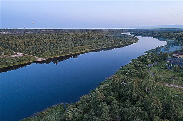
Lena
The largest river in Central Siberia. If we take into account the river, whose basin is located entirely within Russia, then Lena has no equal in length. The main water transport artery of Yakutia. About a dozen ports have been built on it. It is used both for the transportation of goods and passengers, and for tourist purposes. Yakutsk is the main city of the coast. There is a monument to Lena in Olekminsk.
River length - 4400 km
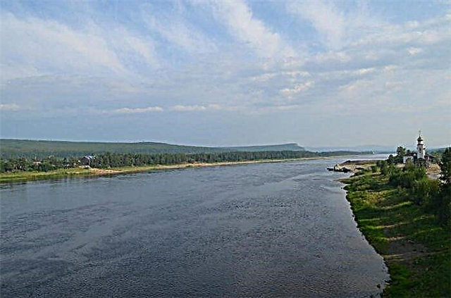
Irtysh
It is shared by Russia, Mongolia and China. It is the main tributary of the Ob. Together they form the largest watercourse in the country. The fish river both in species diversity and in the number of individuals. There are cities on the coast, including Omsk and Khanty-Mansiysk. Sightseeing - the natural park "Bird Harbor", the paleontological monument "Goose Flight".
River length - 4248 km

Ob
Refers to Siberia. It flows into the Gulf of Ob, bringing its waters to the Caspian Sea. It is navigable along its entire length, there are trade routes. Half of the 50 species of fish that are found here are of commercial importance. There is a wide variety of fauna in the vicinity of the channel. The Ob coast is densely populated. Large cities: Barnaul, Surgut, Novosibirsk.
River length - 3650 km

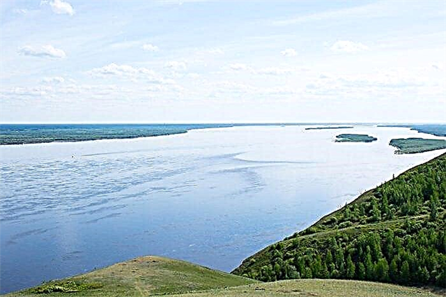
Volga
It carries its waters through the European part of the country. This territory is called the Volga region. The source is located in the Tver region. Connected through canals with 4 seas. 40 species of commercial fish are an important economic component of the region. Many cities are founded on the coast. It is navigable, there are tourist routes that allow you to see their sights. The Volga Day is celebrated on May 20.
River length - 3530 km

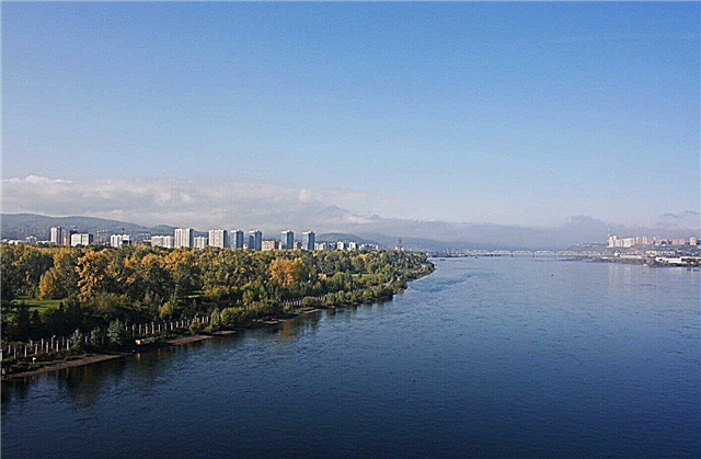
Yenisei
Siberian river flowing into the Kara Sea. Delimits Eastern and Western Siberia. An important transport artery of the region. The Sayano-Shushensky Natural Biosphere Reserve was founded on the left bank. The right tributaries of the Yenisei bring much more water than the left ones. There are disputes regarding the confluence with the Angara: to which of the rivers this section of the channel belongs. Krasnoyarsk is on the coast of the Yenisei.
River length - 3487 km

Lower Tunguska
The right tributary of the Yenisei, belonging to the Irkutsk region and the Krasnoyarsk Territory. High water does not always coincide in time upstream and downstream. In winter, there is almost no food supply for the Lower Tunguska, since the basin belongs to the permafrost territories. Whirlpools and rapids complicate navigation. Large ships can comfortably pass along the river bed only during the flood period.
River length - 2989 km

Amur
Far Eastern river flowing, among other things, along the border with China. It is conventionally divided into three sections, each with a different flow rate. The ichthyofauna is represented by more than a hundred species of fish. There are also endemic species, such as snakeheads. It has been used for shipping since the middle of the 19th century. There are different opinions about the sea into which the Amur flows: either into the Sea of Japan or into the Okhotsk Sea. Major cities of the coast: Blagoveshchensk and Khabarovsk.
River length - 2824 km

Vilyui
The river of Yakutia and the Krasnoyarsk Territory. At the end of the 60s, the Vilyui hydroelectric power station was built, and with it a reservoir. The pool includes 67 thousand lakes. For 5 months, when not covered with ice, it is navigable. The surroundings are rich in minerals. Wharfs have been built, their workload is close to maximum. Attraction - "Valley of Death", which is associated with many legends.
River length - 2650 km

Ishim
The longest tributary of the Irtysh belongs to Russia and Kazakhstan. Winter is frosty and summer is hot. It is used to obtain drinking water, as well as as a resting place. Navigation has been open for about half a year. Fishing is active. In the vicinity of the river, the remains of an ancient man were discovered, which are about 45 thousand years old. The ecology is poor.
River length - 2450 km

Ural
It flows in Russia and Kazakhstan, flows into the Caspian Sea. In the past, the river was called Yaik. The current name was acquired in 1775 by order of Catherine II. It delimits the European and Asian parts of the mainland. For the winter it freezes, freeing from ice only in April. The Urals are rich in fish resources. The fishery has been put on stream. Fishing enthusiasts from other regions also come here.
River length - 2428 km

Aldan
The most abundant river-tributary of the country is located in the Far East. There are many lakes in the floodplain. An important transport artery, products of local enterprises, including mining, are delivered along Aldan. There are several large marinas. Explored reserves of gold, mica, coal. Among the commercial fish species, sturgeon and sterlet are distinguished. 3 bridges have been thrown across the channel.
River length - 2273 km
Deer
It originates in the Krasnoyarsk Territory and carries its waters to Yakutia. There are islands of different sizes. The sturgeon fishery is underway. In different years, the river freezes in different ways. Sometimes the freeze-up lasts only a month. The lower reaches are navigable, while higher navigation becomes impossible for a number of reasons: from depth to elevation differences. Near the mouth is the grave of the Pronchishchev spouses - polar explorers.
River length - 2270 km

Dnieper
The fourth longest river in Europe flows through the territory of Russia, Ukraine and Belarus. The Dnieper and its reservoirs are distinguished by the species diversity of algae - one and a half thousand. There are dozens of fish species. There are representatives of the ichthyofauna that are unique for this region. Several dams, hydroelectric power stations and canals have been built. Smolensk can be distinguished from the Russian coastal cities.
River length - 2201 km

Kolyma
The river of Yakutia and the Magadan region. It is highly dependent on precipitation, almost equally from snow and rain. The average annual water temperature is low. Ice appears in October, breaks open in May. Navigation for no more than 5 months a year. There are commercial fish species including omul and whitefish. Explored reserves of gold. A hydroelectric power station is operating, and another one is under construction.
River length - 2129 km

Don
Refers to the western part of the country. The fifth river in Europe for this indicator. Active navigation along almost the entire length. There is a hydroelectric power station with a dam. There are about 70 species of fish. Fishing is underway, tourist fishermen are attracted. Since the land around is fertile, plowing has led to a reduction in wild fauna. In Rostov-on-Don, there is a monument to the river called "Don-Father".
River length - 1870 km

Podkamennaya Tunguska
It is located on the territory of the Irkutsk Region and the Krasnoyarsk Territory. Mainly a mountain river with rapids, but the upper reaches are located in the valley. The water level is unstable, lower in summer and winter. The river is navigable for more than half of its length. At the same time, there are restrictions for different types of ships. The bandwidth is high. In the vicinity of the reservoir, the Tunguska meteorite fell.
River length - 1865 km

Vitim
The right tributary of the Lena, belonging to Eastern Siberia. Freezing up from November to May. The main attractions are associated with archaeological excavations.For example, sites dating from the Stone Age, which were found near the village of Mamakan. There are deposits of gold and jade. Vitim attracts rafting enthusiasts. The rapids of the river are considered formidable.
River length - 1837 km

Pechora
It flows in Komi and Nenets Autonomous Okrug. The name translates as "cave". A commemorative cast-iron plate is installed at the source. The summer and winter periods are characterized by a clear decrease in the water level. Used for shipping, including accepting sea ships. Docks have been built even in small towns. Commercial species include whitefish and salmon. Reserves of coal, gold and gas have been explored.
River length - 1809 km

Kama
Belongs to the European part of the country, a tributary of the Volga. It has about 74 thousand tributaries. It flows into the Kuibyshev reservoir. It is believed that the bed of the Kama has changed over time, since the reservoir has existed since prehistoric times. In the floodplain, old women are visible with the naked eye. They are especially typical for the upper reaches, where the river is most meandering. A hydroelectric power station is functioning, there is a cascade of reservoirs.
River length - 1805 km

Chulym
It flows through the territories of Khakassia, the Tomsk region and the Krasnoyarsk Territory. It is a tributary of the Ob. Freezing up from November to April. It is navigable on most of the channel, but there are difficult sections in terms of navigation. Chulym is winding, there are rifts that give rise to picturesque landscapes. The ichthyofauna has more than 50 species. There are settlements of one of the Turkic ethnic groups.
River length - 1799 km

Angara
The only river flowing from Lake Baikal. Practically not covered with ice for the winter. Fish are plentiful, especially large representatives of sturgeon are found. Due to the height differences of the riverbed, Angara is perfect for the construction of hydroelectric power plants. Currently 4 are operational. This has helped to streamline shipping and create reservoirs. The main city of the coast is Irkutsk.
River length - 1779 km

Indigirka
Belongs to the northeast of Yakutia. In the past it was called the Western Kolyma. Most of the channel is on the plain, the rest of the section is in the highlands. Since there are rapids, Indigirka is popular with rafting enthusiasts. Gold is mined in the river basin. Sightseeing: the "disappeared" city of Zashiversk and the Big Gorge, which stretches for 100 km.
River length - 1726 km

Ket
The right tributary of the Ob, flows in Siberia. Part of the channel is characterized by turns, the formation of convolutions, zones with shallow water on the verge of drying out. There are many settlements on the coast, but they are all modest in size. In the past, there was a navigable canal linking Ket with the Yenisei. It turned out to be unclaimed and ceased to exist at the beginning of the last century.
River length - 1621 km

Argun
The river is shared by Russia and China. The translation of the name is "winding river", which corresponds to reality in our days. Navigation is limited in time of the year, and is also completely absent in some areas. There are more than 60 species of fish, chum salmon and carp are fished. Big environmental problems. The sources of pollution are on the side of the eastern neighbor.
River length - 1620 km

Tobol
It belongs not only to Russia, but also to Kazakhstan. The right bank is higher than the left. Tobol is navigable for almost a third of its length. Used for timber rafting. Several reservoirs have been built to regulate the flow. More than 20 thousand lakes are included in the river basin. In winter, it freezes unevenly. Kurgan and Tobolsk stand out among the settlements on the coast.
River length - 1591 km

Alazeya
Yakutsk river flowing into the East Siberian Sea. The meanders and channels are characteristic of the entire length of the channel. High water lasts longer than most bodies of water. The Alazeya basin includes about 24 thousand small lakes. There are permafrost zones along the coast. Fish are fished, although not as actively as in other rivers in the region.
River length - 1590 km

Oka
It flows through the European part of the country through several regions. More than 70 permanent bridges have been thrown across the river. Over the course of several decades, the depth gradually decreases. There are large cities on the coast, including Oryol, Ryazan, Nizhny Novgorod. Traveling along the Oka, you can make stops there and see numerous sights.
River length - 1500 km

Amga
Yakutskaya river, the longest tributary of the Aldan. The translation of the name is "gorge". Due to the snow supply, a period of high floods occurs in spring. The banks are of different heights, which creates interesting panoramic views. One of the most popular tourist attractions is rafting. Catamarans and boats of various types are used as a floating craft. August is the best bite of the season.
River length - 1462 km

Olekma
The Lena tributary belongs to three constituent entities of the Russian Federation at once: the Amur Region, Yakutia and the Trans-Baikal Territory. There is a developed boat navigation, the route connects the river with the Transsib. The basis of the ichthyofauna is arctic freshwater. In 1984, the Olekminsky Nature Reserve was created in the delta. Its goal is to preserve local forests of the mountain-taiga type and restore cedar groves.
River length - 1436 km

White (Agidel)
It is one of the main rivers of Bashkiria. It is a tributary of the Kama. The right bank is higher than the left one almost along its entire length. The channel abounds in bends and diverges into branches. The ichthyofauna has changed over time, some species have practically disappeared. More than a third is navigable. A hydroelectric power station was built, a reservoir was formed with it. The largest bridges across Belaya are in Ufa.
River length - 1430 km

Kotui
Located in the Krasnoyarsk Territory. Crosses two lakes: Dupkun and Harpichi. For the winter period it is covered with ice. The coast is picturesque in some places. There are gentle areas, but there are enough rocky ledges without any vegetation at all. Strong winds can rise. Navigation is limited: mainly maneuverable boats and small ships move along the channel.
River length - 1409 km

Pelvis
River of Western Siberia. When it flows into the Kara Sea, it is divided into several branches. Mixed food: snow and dirt. Since the former prevails, the water level rises in the spring. It is navigable downstream. Fishing is on stream. First of all, whitefish are caught, but there are more valuable species, such as sturgeon. There are small villages on the coast.
River length - 1401 km

Vyatka
It flows through the European part of the country. The largest tributary of the Kama. Differs in a change in the direction of the current and a winding channel. Downstream there are sharp differences in width and shallows. Covered in ice from November to April. A number of cities are based on the river, including Kirov. In some areas, navigation is constant, as is fishing. Vyatka is crossed by railway and road bridges.
River length - 1314 km

Zeya
The largest river in the Amur basin. Several hydroelectric power plants have been built, thanks to which the area around it has ceased to be exposed to constant hazards due to floods. Rich ichthyofauna characteristic of different latitudes. There are hunting grounds in the vicinity, but you need to obtain a license to shoot wood grouse and other animals. There are many settlements on the coast, including Blagoveshchensk.
River length - 1242 km

Uda (tributary of the Taseeva)
It flows in the Krasnoyarsk Territory and the Irkutsk Region. Upstream you can find rapids of high difficulty of passage. This route attracts rafting enthusiasts. The main tourist attraction is water trips. It is not convenient to get to all zones by land transport; sometimes you have to use a helicopter. Freezes in mid-autumn. Nizhneudinsk is on the river.
River length - 1203 km

Markha (tributary of the Vilyui)
Belongs to the territory of Yakutia. The area is distinguished by particularly harsh winters. Along the banks there are permafrost zones. For at least 5 months a year, the river freezes over. There are many proven mineral deposits. Diamonds are mined in the delta. The shipping is temporary and with restrictions for various vessels. During this period, passengers are transported according to the schedule by the motor ship "Zarya".
River length - 1181 km

Demyanka
Located in Western Siberia. It originates in the Omsk region, is a tributary of the Irtysh. Along the river bed there are swamps, dark coniferous taiga, forests of various types. There are no large cities in the river basin, the settlement is of a focal character. This is largely due to the difficulty of running the economy. Shipping is irregular, timber is rafted along Demyanka. There are oil fields.
River length - 1160 km

Anadyr
Geographically it belongs to the Chukotka Autonomous Okrug. Fogs often appear over the river. The banks are covered with different types of tundra vegetation. There are no forests in the area, but there are small groves. Ice lies on the river for more than 200 days a year. There are a lot of fish, especially chum salmon - the largest population in the north-east of the country. Reserves of coal and gold have been explored from mineral resources.
River length - 1150 km

Omolon
River in the northern part of the Far East. The largest tributary of the Kolyma. Changes in temperature and severe winters did not prevent hundreds of plant species from taking root on the coast. These places are famous for being the most suitable for elk: their population is higher than in other regions. It is navigable at half its length from the mouth. There are two reserves, Omolonsky and Losiny.
River length - 1114 km

Selenga
It flows not only through the territory of Buryatia, but also through Mongolia. The largest of the rivers flowing into Lake Baikal. Half of the annual inflow of water into the lake comes from the Selenga. Coal is mined in the basin, there are mineral springs. Tourists have access to boat trips. There are many archeological monuments of different periods on the coast. On the coast is the capital of the republic Ulan-Ude.
Length - 1024 km