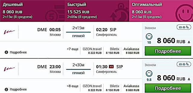
Crimea is famous for its nature: the Black Sea coast, mountains, lakes. This is associated with some problems of the household plan: from the lack of drinking water, to difficulties with farming. In Crimea, there is only one river more than 200 kilometers long - Salgir. The next one on the list - Chatyrlyk - reached the mark of 100 kilometers. The rest are much shorter.
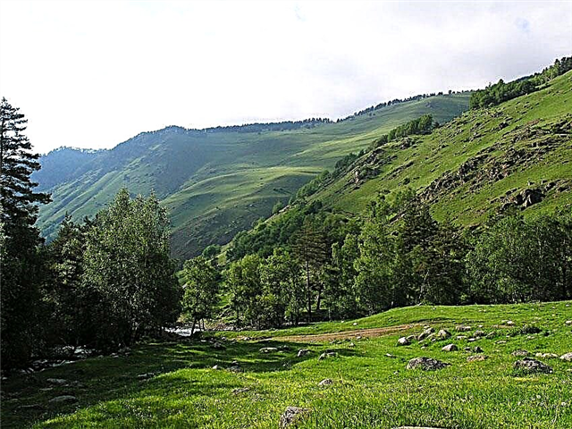
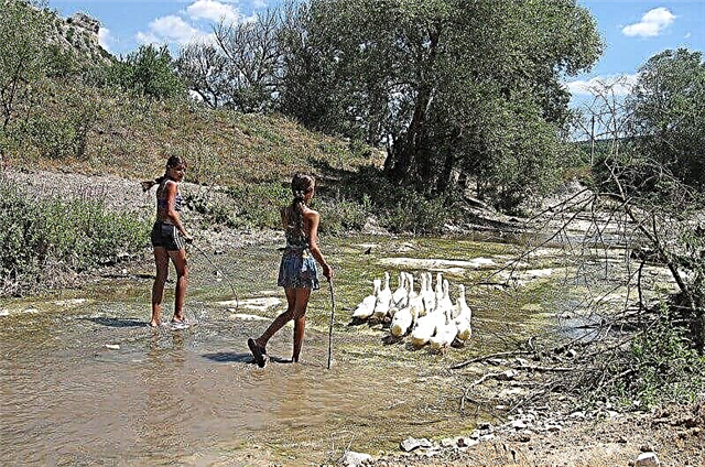
The rivers of Crimea are traditionally shallow. They dry up partially in the summer. However, opportunities for tourism do not disappear even at this time. In the upper reaches of the Salgir, fishermen hunt for trout. There are dams with paid fishing on Vorontsovka. There are many interesting sights in the Belbek valley. And Sudak is completely part of the Black Sea coast resort.
The longest rivers of Crimea
List of the largest rivers in the region by length.
Salgir
The longest river in Crimea. For three months, the channel below Simferopol dries up almost completely. Salgir freezes, but not every winter. The banks are partially landscaped: parks and recreation areas are found both on the territory of settlements and outside their borders. The water of the river is needed for the functioning of the local CHP. Fishing is a popular activity in the area. Trout is found in the upper reaches.
The length of the river is 232 km.

Chatyrlyk
The source is located near the village of Novosyolovskoye. The river's water is used to irrigate fields and gardens. For this, part of the channel had to be straightened. In the middle of the last century, the estuary was separated from the Karkinitsky Bay by a dam. Fish is still being raised in the resulting ponds, which cover an area of more than 2 hectares. Unlike mountain rivers, Chatyrlyk does not depend so much on seasonal rainfall.
The length of the river is 106 km.

Alma
On the banks of the river there are apple orchards, to which the reservoir owes its name: it is translated from Crimean Tatar as “apple”. The upper reaches of the Alma belong to the territory of a nature reserve. Kuzhma - brook trout occurs in this section of the channel. The main tributary is the Savlukh-Su, which is considered a healing source. An Orthodox monastery was built next to it.
The length of the river is 87.8 km.

Biyuk-Karasu
In the lower reaches, it is the largest tributary of the Salgir. It originates from the Karabi-Yayla mountain range. Two reservoirs have been built on the channel near Belogorsk. In the river valley there is a natural monument White Rock or Ak-Kaya rock. Fish are found in the pools, although large individuals are rare. In summer, the river shallows so much that in some areas you can jump from one bank to another.
The length of the river is 86 km.

Kuchuk-Karasu (Malaya Karasevka)
Flowing through the Kok-Asan gorge, the river forms the Cheremisovskie waterfalls. This part of the channel is included in one of the most popular hiking excursion routes. Here you can also plunge into the "baths of youth". In the mountainous area, the banks are steep, covered with forests. In the district there are many monuments associated with the events of the Great Patriotic War. In those years, the region was considered partisan.
The length of the river is 77.6 km.

Burulcha
A tributary of the Salgir with a source on the northwestern slopes of the Tyrke-Yayla Upland. In the lower reaches it dries up strongly in summer and autumn. Rainfall significantly affects the water level in the channel. On the banks of the Burulchi there are two horse-drawn turbayz: the one of the same name and the “Volnaya Stanitsa”. In the upper reaches there are several notable natural sites: the Suyuk-Jailau and Yarma-Chokrak springs, as well as the Khadzhikhoba and Golubinnaya caves.
The length of the river is 76 km.

Kacha
It originates on the slopes of the Crimean Mountains and flows into the Black Sea. Runoff decreases in summer due to the active use of water for irrigation of fields. However, the river does not dry up even in the lower reaches. Two reservoirs have been built on a wide channel. When crossing the Kachinsky Inner ridge, the Kachinsky canyon is formed, otherwise called the Kachinsky gate - a gorge with steep walls.
The length of the river is 69 km.

Belbek
The deepest river in Crimea. It is formed by the confluence of the Biyuk-Uzenbash and Managotra rivers. 5 km from the Sevastopol Bay it flows into the Black Sea. In the 80s of the last century, a second channel was laid in the lower course to prevent spills. Now there is water only in a new channel. In the Belbek valley, there are iconic sights - the Chelter-Koba cave monastery and the Syuyren fortress.
The length of the river is 63 km.

Zuya
It originates on the slopes of the Dolgorukovskaya Yayla massif. To the south of the village of the same name, the river is dammed up. Not far from the Balanovsky reservoir formed there, there is an early Paleolithic site called Kiik-Koba. It is best to visit the river valley in winter or spring when the water level is rising. Of the six tributaries, the main one is Besh-Terek, which is only 8 kilometers shorter than the Zuya.
The length of the river is 49 km.

Western Bulganak
Refers to the low-water rivers of the Crimea. It originates on the slopes of the Inner ridge of the Crimean Mountains. It flows into the Kalamitsky Gulf. During the melting of snows or during the period of heavy rains, temporary tributaries appear near the Western Bulganak - gullies and ravines. The reservoir is important for agriculture, since there is no alternative to it. In the river valley there is a settlement founded in the 2nd century BC.
The length of the river is 49 km.

Wet Indole
River in the eastern part of the peninsula. It flows into the Eastern Bulganak, together with which it is practically not regulated. On one of the tributaries of the river - the Zmeinaya gully - the Lgov reservoir was built. On the right bank of the Wet Indole, the Toplovsky Holy Trinity Paraskevievsky Orthodox convent was founded. There are many gardens on the left bank, and in general the vegetation in the valley is lush.
The length of the river is 49 km.

Eastern Bulganak
The main part of the basin belongs to the territory of the steppe Crimea. In the summer, the river dries up almost completely, and in the upper reaches there is no water in the channel for most of the year. The river has nine tributaries, both permanent and temporary. For example, beams named Kolpak and Murzakoiskaya. Thanks to an artificial channel, the waters of Wet Indole are transferred to Eastern Bulganak.
The length of the river is 48 km.

Beshterek
The largest tributary of the Zuya. The translation of the name from the Crimean Tatar language is “five trees”. It originates on the slopes of the Dolgorukovskaya Yayla. There are mushroom spots in the nearby forests. Fish in Beshterek and surrounding water bodies is found, but not large. Interesting objects of the valley: Beshterek-Kobasy cave-grotto, a spring and a small waterfall not far from an abandoned military unit.
The length of the river is 42.2 km.

Samarchik
It flows through the territory of the Razdolnensky district. It flows into the estuary of the Karkinitsky Bay. All five tributaries of the river do not have their own names. In the 60s of the last century, the North Crimean Canal was built. This made it possible to completely change the water regime of the Samarchik valley. Now part of the channel has turned into a waste collector, and drying out has become partial and rare.
The length of the river is 42 km.

Vorontsovka
In the past, the river was considered a tributary of the Chatyrlyk. After the war, a dam and an artificial estuary were built. This changed Vorontsovka. Among other things, it began to flow into one of the Black Sea bays - Karkinitsky. The banks in most of the channel are covered with low thickets. There are several dams on the river. Paid fishing is available for tourists. Some of the gear can be bought or rented locally.
The length of the river is 42 km.

Ali Bai
The source is the southwestern plain of the Kerch Peninsula. The mouth is the Sea of Azov. The river has 12 unnamed tributaries. Not far from the Rybnoye tract, flowing through the Ak-Monay Upland, Ali-Bai forms a salt marsh. In the river valley, there are 6 ponds with a total area of 160 hectares. Soon a protected area may appear here to preserve the steppe flora and fauna.
The length of the river is 40 km.

Black
It flows into the Sevastopol Bay. Chernorechensky canyon is a natural landmark of the peninsula. A reservoir has been built on the river. Part of the coast near the village of Chernorechye is going to be “chained” into concrete.Not far from the mouth are the remains of the medieval city of Avlita, including the Kalamita fortress, and the Inkerman cave monastery. There are rare fish species. The water does not warm up well even in summer.
The length of the river is 35 km.

Churyuk-Su
The easternmost river of those originating on the northern slopes of the Crimean mountains. The reservoir has many names, including Small Indol, Rassan-Bai, Shirin-Su. The valley is densely populated. The absence of karst springs, a modest catchment area, arid terrain as a whole are the reasons for the low water level of Churyuk-Su. In the middle of the last century, a reservoir was built near the city of Stary Krym.
The length of the river is 33 km.

Small Salgir
The river has an unofficial name - Chokurcha, used by local residents. Within the city limits of Simferopol it flows into Salgir. In the 80s of the last century, the channel was artificially deepened. Then the embankment appeared. Over the years, it has lost its luster, but there is a gradual restoration. In the river valley there is the Chokurcha cave - one of the most ancient dwellings on the territory of the peninsula.
The length of the river is 22 km.

Pike perch (Suuk-Su)
The longest river on the southern coast of Crimea. It originates from the Main ridge of the Crimean Mountains. It flows into the Black Sea near the city of the same name. Sudak is a famous resort where people go for a quiet beach vacation. The shores of Suuk-Su are chosen by lovers of hiking and ecotourism. In 2017, due to the flooding of the river after a rainstorm and mud flows, a flood occurred in the vicinity of settlements.
The length of the river is 22 km.

Martha
The right tributary of the Kacha partly flows through the Crimean Nature Reserve. The valley is characterized by dense forests. In addition to the gullies that feed Marta, the river has two relatively large tributaries: Finaros and Yanyker. Several bridges have been thrown across the channel, but some have collapsed from time to time. A monument to the partisans can be found on the shore. The remains of a washed-out dam have been preserved several kilometers away.
The length of the river is 21 km.

Baibuga
The estuary - the Black Sea bay - is located within the city of Feodosia. On the banks of the river there are two villages: Nasypnoye and Blizhnee. The valley around was artificially planted with trees, mainly Crimean pines. This was done to increase the water content of Baybuga. At the beginning of the last century, the Pasha-Tepe mineral spring with a unique composition of water was discovered in the drainage basin of the river.
The length of the river is 20 km.

Kokkoska
One of the "strongest" rivers of the Crimean peninsula with great energy potential. Left tributary of the Belbek. The name is translated from Crimean Tatar as "blue eye". Basically, the river is fed by karst sources. Kokkozka has a picturesque valley, the pool is filled with tall forest, and the channel is characterized by bends, rifts, shoals and rapids.
The length of the river is 18 km.

Bodrak
The left and longest tributary of the Alma. It flows through the Bakhchisarai region. The river has no noticeable tributaries, only unnamed streams. Bodrak becomes full-flowing only in spring, when abundant melting of snow and ice occurs. The current is fast almost along the entire channel, and the water is clear. One of the “Catherine's Miles”, a road sign and a historical object of the 18th century, has been preserved in the river valley.
The length of the river is 17.8 km.

Style
The left tributary of the Kacha, flowing in the south-west of the Crimea peninsula. The source is located at the Yalta Yaila, and the river flows into the Zagorskoye reservoir. The style takes several tributaries-beams, but they are insignificant. The channel has a low tortuosity coefficient. There are picturesque places in the valley that tourists often choose as camping sites during hiking.
The length of the river is 17.2 km.